Hawaiʻi coordinate systems: State Plane zones, UTM 4N & WGS84
Most Hawaiʻi GIS data uses one of three coordinate systems: NAD83 State Plane (one zone per island group), UTM zone 4N on NAD83(HARN), or WGS84 / Web Mercator for web maps. Here is which one to use and where you'll see each.
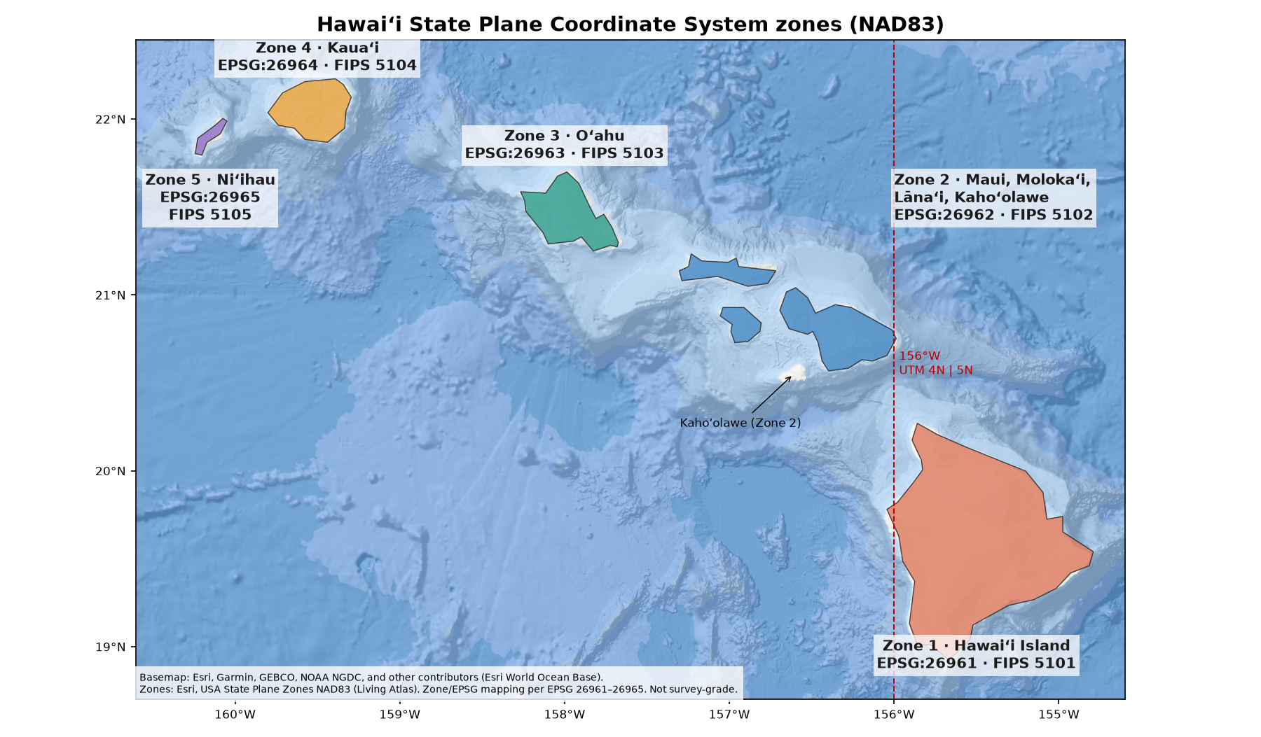
State Plane (NAD83), Hawaiʻi zones
| Zone | Islands | EPSG (meters) |
|---|---|---|
| 1 | Hawaiʻi Island | 26961 |
| 2 | Maui, Kahoʻolawe, Lānaʻi, Molokaʻi | 26962 |
| 3 | Oʻahu | 26963 · US survey feet: 3759 |
| 4 | Kauaʻi | 26964 |
| 5 | Niʻihau | 26965 |
NAD83(PA11) is the Pacific-plate realization of NAD83 used with modern CORS in Hawaiʻi (epoch 2010.00). Esri publishes matching State Plane definitions (e.g. NAD 1983 (PA11) StatePlane Hawaii 1–5). Many older county and State layers still use NAD83(86) or NAD83(HARN)—check the layer metadata and apply a geographic transformation when mixing them. An older Esri poster (Apr 2013) also illustrated county-to-zone labels and PA11 shifts; this page uses the current Living Atlas zone layer instead.
UTM zone 4N, NAD83(HARN): the State GIS standard
The Hawaiʻi Statewide GIS Program publishes its data in UTM zone 4N, NAD83 HARN (meters). The statewide TMK metadata says so, and the State's ArcGIS services report EPSG 3750 (Esri WKID 102202). EPSG defines 3750 for onshore Hawaiʻi between 162°W and 156°W. The State uses zone 4N for all islands, even the part of Hawaiʻi Island east of 156°W.
WGS84 and Web Mercator
The State geoportal exports data in WGS84 (see Statewide GIS). Online basemaps and ArcGIS Online use Web Mercator (EPSG 3857). Reproject to State Plane or UTM before measuring distance or area.
Coming: NSRS modernization
NOAA's National Geodetic Survey (NGS) will replace NAD83 with four new terrestrial reference frames tied to ITRF2020. Hawaiʻi falls under PATRF2022 (Pacific). A new geoid-based vertical datum will also replace the current vertical datums. NGS is also defining a new State Plane system, SPCS2022. Until those are released, keep using NAD83.
Sources checked Oct 27, 2026 ~10:17 AM HST (map set to latest Esri Living Atlas State Plane zones). Always use the coordinate system your contract or metadata names.
Sources
- https://apps.epsg.org/api/v1/ProjectedCoordRefSystem/26961/ — checked Oct 27, 2026 (HST)
- https://apps.epsg.org/api/v1/ProjectedCoordRefSystem/3759/ — checked Oct 27, 2026 (HST)
- https://apps.epsg.org/api/v1/ProjectedCoordRefSystem/3750/ — checked Oct 27, 2026 (HST)
- https://files.hawaii.gov/dbedt/op/gis/data/tmk_state.pdf — checked Oct 27, 2026 (HST)
- https://geodata.hawaii.gov/arcgis/rest/services/AdminBnd/MapServer?f=json — checked Oct 27, 2026 (HST)
- https://geodesy.noaa.gov/datums/newdatums/index.shtml — checked Oct 27, 2026 (HST)
- https://geodata.hawaii.gov/arcgis/rest/services/Terrestrial/MapServer/3 — checked Oct 27, 2026 (HST)